


Where the lines are drawn: New redistricting committee may upend political landscape
Map credit: Public domain. Department of the Interior – National Atlas of the United States
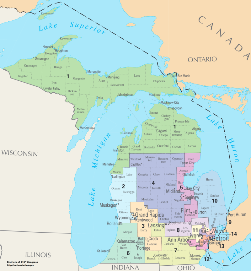
Michigan’s current congressional districts, shown here, are in the process of being redrawn.
Michigan’s congressional districts, state senate and state house districts are currently being redrawn, and the decisions made by the mapmakers are likely to influence the results of the 2022 midterm elections. Because Michigan’s population is growing slower than the U.S. population overall, the state will lose one of its 14 U.S. House districts in this cycle of redistricting.
In 2018, a group of activists known as Voters Not Politicians organized to end partisan gerrymandering in Michigan. Partisan gerrymandering is the practice of drawing the boundaries of political districts to create an unfair advantage for a political opponent. Racial gerrymandering is when districts are drawn to dilute the voting power of minorities.
They successfully got the Independent Redistricting Commission Initiative (also called Proposition 2) on the ballot, passing with 61% of the vote in the 2018 election. The initiative took away the power to draw political boundaries from the state legislature and instead established a committee of 13 random citizens to create Michigan’s political districts.
The Michigan Independent Citizens Redistricting Committee (MICRC) released the first of their draft maps (covering southeastern Michigan) on Aug. 20. They are expected to release more maps, including those of West Michigan, in the coming weeks.
Chimes interviewed geography professor Mark Bjelland and political science professor Doug Koopman to learn more about redistricting and gerrymandering.
“The pros and cons [of MICRC] really depend on the biases an observer brings to it,” Koopman wrote in an email to Chimes, adding that “the main characteristic of the Michigan commission is that collectively it doesn’t have any experience in drawing district lines, and so brings both ‘fresh eyes’ but also a certain naivete to it all.”
“It’s a huge change, but they have a couple challenges,” said Bjelland. “The census data came late, mostly because of the pandemic, and there has been a problem with absences on the commission.”
Bjelland explained that before the independent commission, there were accusations that republicans in the state legislature were gerrymandering districts to their advantage.
“The most egregious past Michigan gerrymandering is/was in state House districts,” Koopman wrote. “Most of this is in the Detroit area and its suburbs, but Michigan House District 76 in the Grand Rapids area is pretty ugly, too, wrapping around the west, north, east, and a little southeast sides of Grand Rapids city.”
Racial gerrymandering, as well as partisan gerrymandering, has been a problem in Michigan. Bjelland noted that the Voting Rights Act protects certain predominantly Black districts in the Detroit area from being split up.
Koopman explained that the courts are tougher on racial gerrymandering than on partisan gerrymandering.
“A few times judges have found [partisan gerrymandered] districts just ‘too ugly’ to allow, but there really is no fixed standard and most courts don’t want to set a fixed standard because it would look too strongly like judicial interference in an inherently partisan activity,” Koopman said.
The rise of Geographic Information Systems (also known as GIS) gives gerrymanderers detailed information about where voters for the opposite party live, Bjelland told Chimes. Computer mapping also allows politicians to draw precise maps that pack opponents’ votes into one district, spreading the opposition among many districts so that they can’t win anywhere.
“It is the combination of partisan control [of the redistricting process] and these sophisticated Geographic Information Systems that makes gerrymandering more dangerous today,” Bjelland said.
According to Bjelland, what allows gerrymanderers to figure out where voters for the other party live has to do with a larger trend in political geography.
“Increasingly, Americans are sorting themselves out, living by like-minded people. Where you live predicts how you’re going to vote,” he said.
Koopman said that districts don’t have to be distorted to be gerrymandered. “A district whose lines look nice and straight … can still be gerrymandered by party or race,” he said. “So, while the visual ‘look’ of districts is important, it is not the only criteria for evaluating a fair and competitive single district, or a general competitiveness of all districts in any one election.”
Reflecting on how Michigan gerrymandering compares to the rest of the country, Bjelland said that “Some analysts think that we’re pretty extreme.”
Koopman shared a different view on this, writing “I personally think Michigan is NOT in the top 25% of partisan redistricting states now, but ‘only’ a little worse than average.”
Looking to the future, Bjelland noted that West Michigan has two of the fastest growing counties in the state: Ottawa and Kent. Ordinarily, this would mean that the congressional districts surrounding them would shrink, but Michigan’s loss of a district changes this.
Bjelland anticipates that much of the debate about the new maps will stem from a vague clause in the Michigan constitution.
“Districts shall reflect … communities of interest,” reads the passage of the constitution. “Communities of interest may include, but shall not be limited to, populations that share cultural or historical characteristics or economic interests.”
But this definition still leaves room for interpretation. “I think that the debates are going to be ‘What constitutes a community of interests?’” said Bjelland. “[And] who defines communities?”
As to how redistricting will change the political landscape, Koopman said “it all depends on where the lines are drawn.” He explained that Kent County’s population is about 85% of the population of a U.S. House district, and so if Kent County is the center of a new district, some portions of the surrounding counties will be added. “Most of these ‘adds’ would be more strongly Republican, so the most likely result is a lean-slightly-Republican U.S. House district for the Grand Rapids area,” said Koopman.
“A well-suited Democrat, a poorly fitting Republican, and the right dominant issues, could conceivably flip the district to Democrats. Right now, I see that as unlikely but it could be,” Koopman added.
The redistricting commission is looking for public input as their work continues. People who want to comment on the mapping process can voice their thoughts on the MICRC’s website at https://www.michigan-mapping.org/.